 We thought that once we were done sailing we would never have to wait for a “weather window” to go anywhere ever again. Turns out we were wrong. From Fairbanks, the Arctic Circle is just a tantalizing 200 miles away – it was calling to us like a siren. But there’s only one way to get there and that’s to take the Dalton Highway. The highway is a tough road in any season (it has been featured on the TV show Ice Road Truckers). It’s partly gravel and partly paved, but the paved sections are the roughest – riddled with potholes and frost heaves. The BLM website advises you to bring two full spare tires and extra fuel, just in case. We decided to take our chances with our single spare tire, but we waited in Fairbanks until the rain let up so the conditions on the road might be a little less muddy.
The road winds its way through black spruce forest into the treeless tundra. It goes all the way to Prudhoe Bay on the Arctic Ocean, but the last stretch from the town of Deadhorse to Prudhoe Bay is restricted because of the oil field operations there. Only sanctioned tour groups can go into the restricted area. We had originally hoped to dip our toes in the Arctic, but it was just too cost-prohibitive to get up there on this trip (guided tours are several hundred dollars per person). We decided to just drive ourselves as far as the Circle instead.
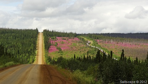
The highway, a patch of bright-pink fireweed, and the pipeline
 The northern section of the Trans-Alaska pipeline runs mostly parallel to the Dalton Highway, sometimes crossing under the road but always within sight of it. Much of the pipeline is elevated instead of being underground because the crude oil is too warm – at temperatures of 115 to 145 degrees Fahrenheit it could thaw the permafrost below the soil, causing it to become unstable. Surprisingly, there are lots of places where you can pull off the road and get a closer look.

 After about five hours of driving at speeds.as low as 25 mph (trying to avoid the potholes and minimize the teeth-rattling washboard sections), we finally reached the Arctic Circle at 66 degrees 33 minutes North latitude, or so the sign claimed. However, due to the Earth wobbling a bit on its axis the Arctic Circle is slightly further north than the sign. Supposedly it is moving northward at about 49 feet per year (Kevin was the one who did all this research; he says you can look it up if you want to). So just to be sure, we drove about an extra minute of latitude north. (We are nerdy that way.) But we still took a photo at the sign, anyway.


Ha - we would have done the same thing!
ReplyDelete