Saturday, June 30, 2012

Yellowhead Highway to Prince Rupert, BC

We’ve spent the past two days exploring the Canadian port town of Prince Rupert.  The town boasts the deepest ice-free harbor in North America, and is the nearest major North American shipping port to Shanghai, China (a couple of fascinating factoids we learned when we took a tour of the port authority’s visitor center).

The town was founded in 1910 and many of the buildings from its early days have been preserved.  There are lots of pubs and shops near the town docks in an area called Cow Bay – so named because a farmer once had a herd of cows shipped here via barge.  All of the trash cans, signposts, etc have a dairy cow theme.  Some businesses have taken the cow theme even further, one of the notable cafes is called Cowpuccino’s.

DSC03577

The town’s Museum of Northern British Columbia showcases the town’s history and has a wonderful collection of First Nations art and artifacts, including masks, ceremonial costumes, and traditional cedar bent boxes.  I was fascinated by this shaman’s headdress – made of long pointy Grizzly bear claws.

There was a temporary exhibit on Asian and Pacific Islander masks.  But one of the ones on display looked a little out of place to me.  What do you think?

We also took a tour of the North Pacific Cannery Museum, just outside town.  It was established in 1889 and ran continuously for almost 100 years.

DSC03631

Our tour guide was an elderly man who got his first job working here at age 13 or so.  He took us around all the buildings and explained the entire canning process for salmon.  He was even able to fire up all the assembly line machinery to demonstrate how it worked.  In the early days it could take workers up to 20 hours or more to unload, clean, process and can the fish by hand.  Once electric machinery was introduced, the work took less than 2 hours.

The tour also delved into the daily lives of the workers here, taking us through several bunkhouses and houses for the managers and their families.  Our guide had lots of personal anecdotes about the different groups of workers (Europeans, Japanese, Chinese, and First Nations) and how they all interacted with one another.  The guided tour of the facility really brought this fascinating piece of history to life.

DSC03645

Friday, June 29, 2012

Great Alaskan Road Trip: Week 7 Roundup

Each Friday, I post some relevant (and not-so-relevant) stats about the trip, as well as a little write-up of what it’s like to live out of a van for weeks on end. Here’s where we are overall:

  • Total miles driven: 5077
  • Total days on the road: 46
  • Total miles hiked: 77.3  (no new miles hiked this week – trails too muddy from all the rain)

We think this is a juvenile bald eagle, but aren’t 100% sure

Here are some interesting stats for this week:

  • Fuel stops: 2 (diesel: $4.59 / gallon at the Junction of Hwy 16 and 37; $4.68 in Terrace, BC – gas costs more here than in Jasper, AB thanks to BC’s higher provincial gas taxes.  Bleh.)
  • Technical issues: 3 (The plastic bathroom door handle broke off, the water pump “On” switch light burnt out, and there was a leak around the TV antenna that got under the headliner.  Plus, the rivets on the bathroom vent still leak – luckily there is a shower drain on the floor in there.)
  • National Park Service sites visited: 0 (Lots of great Provincial Parks in BC, though)
  • Birds of Prey sighted: 4 adult Bald Eagles and 2 juveniles (we think).
  • Moose sighted: 2 (still no males with antlers, though.)
  • Bears sighted: 6 (Black bears, but no Kermodei Spirit bears, sigh.)

So our trip is nearly one-third over.  We’ve enjoyed seeing this part of Canada – even with all the rain and mist clouding up the views of the mountains, it’s still been pretty scenic.  But we are hoping we see some sunshine in Alaska – I am tired of all our pictures having washed-out gray skies!

Speaking of rain, we’ve had a little bit of rain get into the van thanks to a couple of leaks.  There are two ceiling vents on the van – one in the bathroom and one above the kitchen – and Kevin sealed them both pretty well before we left on this trip.  However, the bathroom van is leaking from the rivets in the plastic.  It’s really a manufacturing defect – Kevin can seal the rivets with silicone if only we had a ladder (and a dry day for the silicone to cure).

As to the leaking around the TV antenna, we are thinking what happened was that one of us didn’t quite close the kitchen ceiling vent all the way and some water got under there when the van was parked on a downward slope.  Then the water trickled forward and leaked out around the TV antenna crank.  It only happened the one time, and we haven’t seen it leak since, so we’re hoping this issue has fixed itself (and we’re now more diligent about making sure the vents are completely closed).

DSC03453The broken bathroom door handle is just an aesthetic nuisance at this point.  A big piece of the plastic broke off, but we are still able to get the door open and closed.  When the trip is over, Kevin will replace the door handle but for now it’ll have to do.

The water pump light used to glow red and let us know when the pump was on – there’s no “on/off” label near the switch.  We like to turn it off at night because it’s kind of loud and every once in a while the pump will start running and wake us up.  So now that the light is burnt out, we needed a way to figure out at a glance if the pump is on or not.  Sometimes the simplest solution works best.

DSC03452

As you can tell, I am running out of material to write about as far as life on the van goes (things break, the roof leaks, it’s cramped, etc).  I don’t want to repeat myself so for next Friday’s roundup I am asking you guys if there’s anything you want to know more about.  If you have a question or topic suggestion just email me or comment below.  Otherwise next Friday’s post will probably be more photos of broken things and/or puddles on the floor.

Thursday, June 28, 2012

Yellowhead Highway to Terrace, BC

We are here in Terrace for two nights (we are a bit ahead of schedule to catch our ferry on the 1st), so today we took a little road trip north of town to the Nisga’a Memorial Lava Bed Provincial Park.  The park is located on the site of Canada’s most recent volcanic eruption.  A small volcano erupted in the 1750’s, causing enormous amounts of damage to the forest and completely destroying two native villages – more than 2,000 people were killed in the disaster.

What’s left now is an eerie landscape of lumpy lava rock (called a’a lava).  Up to forty feet thick in some places, the lava beds cover an area almost 70 square miles.  It looks like an alien planet, especially since all the rock is coated in gray-green lichen and moss – the first signs that the forest will one day reclaim all the land that was lost.

DSC03568

We drove to the park’s visitor center, a traditional Nisga’a longhouse, but unfortunately it is closed weekdays until July 1st.  Too bad, it looked kind of cool.

There are other sights to see in the park, though – there are two waterfalls and a lake that was formed when the lava dammed up a river.  Thanks to all the recent rain, all the water levels are extremely high which made it pretty exciting to step out to the viewing platform at Vetter Falls.

We enjoyed the daytrip, but we had ulterior motives for heading to this part of the area: our RV campground host had mentioned that there was a Kermodei bear, or Spirit Bear, living up this way.  The Kermodei bears are black bears with white coats.  They aren’t albinos, it’s just a recessive gene mutation (both parents need to pass on the gene to make a white bear).  We kept our eyes peeled and drove slowly the entire way (and probably pissed off all the drivers who had to pass us), but we didn’t see any Spirit Bears.  They’re fairly rare – less than 10% of the bear population in this area are Kermodei bears.  We did see four other regular black bears along the way, but somehow they aren’t quite as exciting now that I am on the hunt for a photo of the elusive Spirit Bear.  Here’s one I found on the internet:

spirit_bearcub1

Photo courtesy of www.kermode-terrace-bc.com

And here’s a Spirit Bear I saw standing on a street corner in Terrace (they are the town mascot):

Wednesday, June 27, 2012

Stewart-Cassiar Highway --- Hyder, Alaska

We first set foot in Alaska a few days earlier than originally planned, thanks to our detour up the Stewart-Cassiar Highway.  And crossing the border was a breeze – the US doesn’t even maintain a border patrol station here (the building on the left in the photo is Canada’s Customs & Immigration, coming back the other way – it’s manned 24 hours a day, seven days a week, if you can believe it.  I guess Canadians are even more worried about the riffraff getting in than we are).

So yep, we just waltzed right into Hyder, Alaska, population 100 (give or take).  Despite it’s gold-mining past there is, to be honest, not much here these days except a few hardy residents and one of the best places for bear-watching in all of Alaska.  (Too bad for us that we are about a month early to catch the salmon run at Fish Creek – no bears today!)  One item of note is that the pavement ends at the border – all the roads in Hyder are strictly gravel, no fancy-pants asphalt here!

Our guide book calls the town the “Friendliest Little Ghost Town in Alaska”.  As you drive down the main street (there’s pretty much just the one) you see the shells of old buildings and wonder if there’s something inside, or if the place was abandoned long ago. 

We attempted to drive to the Salmon Glacier, which is about 20 miles down the (gravel) road from Hyder.  Luckily for us, there was construction on the road, reducing it to just one lane.  While we waited for our turn, the friendly stop-sign attendant started up a conversation with us about our van (she and her husband want a Sprinter, too).  She mentioned that the road to the Salmon Glacier just opened yesterday, and that there was still a lot of snow and avalanche activity.  “The road is just carved into the side of the mountain,” she warned, “and there’s about a thousand foot drop on one side.  If you went over, you’d never be found.”  Well, her dire warning gave us pause, so we only went a few more miles before we turned around and headed back into Hyder.  We had a late breakfast at the Glacier Inn to celebrate our near-brush with death.

DSC03496

The Glacier Inn serves breakfast, lunch, and dinner and is one of only three bars in Hyder (the town boasts one bar per 33 residents).  It’s claim to fame is “being Hyderized” – where they have you down a shot of 190-proof, pure grain alcohol.  Well, ten years ago I might have been tempted, but my thirty-something good sense prevailed (that, and the fact that it was still only 10:30 am), so we skipped the Hyderization and just enjoyed looking around at the bar’s décor.  Every wall is completely plastered with currency – one of the signs on the wall claims that the walls are worth more than $50,000.

After breakfast we decided our short foray into Alaska was finished.  There really isn’t any way to get further into Alaska from Hyder – there’s just the one road that leads to and from Stewart.  (I suppose you could leave by air or sea, if you were lucky enough to have a boat or helicopter.)  So we’ve headed back down the Stewart-Cassiar Highway to continue our course west on the Yellowhead Highway to catch our ferry from Prince Rupert, BC to Juneau, AK. 

We are now in Terrace, BC at one of the hands-down friendliest mom-and-pop RV parks we’ve ever stayed at.  Despite the fact that they are completely full, they found a spot for us (with electric hookup) right on their front lawn – and they loaned us their propane grill so we could finally cook the two steaks we’ve had in the freezer since Moab – now that’s service!

Tuesday, June 26, 2012

Stewart-Cassiar Highway Detour --- Stewart, BC

We have a couple of extra days to kill before our ferry to Juneau so we have detoured off the Yellowhead Highway, going north instead on the Stewart-Cassiar (Highway 37).  It’s been a scenic drive, but very misty with rain so some of our photos may look a little dreary.  I’m starting to wonder if the sun will ever come out, it’s been so drizzly lately.  We haven’t seen too many bears (maybe they don’t like the weather, either) but we did run across this guy hiding in the underbrush along the Cassiar highway.

We stopped briefly in the small First Nation town of Gitanyow.  (“First Nations” is the term Canada uses just as we use “Native American”).  Gitanyow is home to some of the oldest totem poles in the world that are still in their original location.  One of these is called “Hole in the Ice” and is approximately 140 years old; our guide book hypothesizes that it might be the oldest standing totem pole in the world.  Unfortunately, we don’t know which one it is since none of them were labeled and the visitor’s center was closed.

The Stewart-Cassiar highway goes north and eventually meets up with the Alaska Highway, but we aren’t going to Alaska that way.  Instead we turned west at highway 37A, a small spur that leads to a pair of quirky towns that straddle the US-Canada border at the top of the Portland Canal – Stewart, British Columbia and Hyder, Alaska.  Both were mining boomtowns in the early 1900’s.

Of the two towns, Stewart BC is the more populated and busy one with a gas station, a few hotels and restaurants, and a couple grocery stores.  Most of the original structures in both towns were actually built on pilings out in the tidal flats of the canal.  The buildings are long gone but many of the pilings remain – eerie reminders of a distant past.

We did cross the border into Alaska once today, but we were only in Hyder for a few minutes before crossing back.  We plan to go back for a little longer tomorrow – stay tuned.

One of the more interesting stops on the Stewart side of the border is the Bear Glacier.  As you approach the town of Stewart on highway 37 you come around a bend in the road and all of a sudden you see this magnificent blue glacier.

I was disappointed that the sky was so cloudy, because these photos don’t really do justice to the color – I tried to get a few close-ups just to show how bright blue it really is.  Seriously, it looks like Superman’s Fortress of Solitude or something.  And the surface is riddled with crevasses – very different from the Athabasca Glacier we were standing on just a few days ago, and not somewhere I’d like to go hiking.  We enjoyed the view from the safety of the road, instead.

DSC03519

And of course, Kevin had to get the requisite shot of the van in front of the glacier.  Look!  They kind of match!

Sunday, June 24, 2012

Yellowhead Highway to Hazelton, BC

Today was a short drive from Smithers to the towns of Hazelton, British Columbia.  I say “towns” of Hazelton because there are three all within a few miles of each other – New Hazelton, South Hazelton, and just plain Hazelton.  We are up near just plain Hazelton (also called Old Hazelton), which is a couple miles north of the Yellowhead Highway via a very high and very scary one-lane suspension bridge.  Kevin made the mistake of looking down; I just kept my eyes glued to the road since I was the one driving.

We made this short detour because we wanted to visit the ‘Ksan Historical Village, a group of reconstructed tribal buildings of the Gitxsan people.  The name Gitxsan translates to “the people of the river of mist”.  They have lived in the area around the Skeena and Bulkley rivers for centuries.

The village was built in the late 1960’s, and all buildings were constructed of cedar planks using traditional methods.  The museum opened its doors in 1970 – seven buildings designed to show others the traditional Gitxsan way of life.

The Gitxsan did not have a written language.  Instead they handed down their history and stories through oral traditions and carvings on totem poles.  We learned that the most important figure on the totem poles is not the one at the top, but the one on the bottom which carries all the weight.

There is a very small ($5 Canadian) admission fee to enter the village, but that only gets you into one building (the museum).  At this time, the other buildings can only be seen with a guided tour ($5 extra).  We decided to take the tour, since the museum was so small that we weren’t going to get much out of the visit otherwise.  The tour took us through three buildings.  The first was the Frog House, a traditional cedar longhouse which is where the clan would have lived all together (up to 60 people at a time).  The second building was the Wolf House, a hall where feasts would have been held with ceremonial dances and shared meals.  And the third was the Fireweed House, where all the ceremonial costumes and treasures are displayed.  We thought the guided tour gave a lot more depth to our visit and we were glad we chose to do it, but unfortunately no indoor photos were allowed.

DSC03416

Tonight we are staying right next door at the ‘Ksan Campground.  Interestingly, when we pulled up the campground was more than half full of big Class A Motorhomes.  We noticed that people all seemed to be wearing similar yellow vests.  One of the ladies told us that they were all starting out on a guided caravan tour – 34 days to see the sights of British Columbia, the Yukon, and Alaska.  The tour leader keeps in touch with them on the road via VHF (of all things!) narrating all the interesting things they are seeing along the roadway.  Curious, we looked up the website on the internet and discovered the guy charges, get this: just under $7,000 (USD) per RV/couple.  The price does not include fuel but does include any admission/tour fees and all campground fees.  But still – seven thousand dollars???!!!!  And it turns out the guy leads three of these tours per summer, up to 18 RV’s in a tour.  He has managed to get people to pay him seven grand so that they can drive their own RV’s (paying for their own food and gas, too) to Alaska and back.  Do the math; we did, and we came away shaking our heads in utter amazement (and kinda wishing we’d come up with the idea first). 

Saturday, June 23, 2012

Yellowhead Highway to Smithers, BC

DSC03399

We stocked up on groceries in Prince George on Friday morning and headed west.  My tentative plan had us stopping for the night in McBride, but we decided to push a little further, spending the night in Beaumont Provincial Park near Fort Fraser instead.

DSC03394The weather has suddenly and miraculously turned sunny and about twenty degrees warmer.  Summer has finally arrived!  After a picnic lunch, we went for a stroll around the campground and nearby Fraser Lake.  The Provincial Parks in BC are very nice and well-maintained, similar to the state parks in Arizona.  Everything was clean, the sites had freshly raked gravel – it was just a really pleasant place.  We were one of the first people to arrive but we could see that many of the sites had been reserved in advance for the weekend.  Many, but not all, so I am a little less concerned about making reservations ahead of time – even without a reservation I think we got a pretty nice spot – tucked into a grove of aspen and surrounded by fluffy white dandelion seed heads.

DSC03396

DSC03402

We continued westward today, stopping briefly in the town of Burns Lake, then continuing on to Smithers, where we will stay the night.  Excellent.  Homer, AK – here we come!

burns-smithersPhoto courtesy of The Simpsons.

I thought there wouldn’t be much to see in the towns along this route, but I guess I spoke too soon.  We saw the world’s largest fly fishing rod today in Burns Lake, so that was exciting. 

DSC03411

And actually, Smithers is a pretty cool little town.  We got here just in time for the farmers market, although at this time of year (too soon for vegetables) it was more like the crafters market.  Then we took a walk around the very quaint Main Street before heading to our campground for the night – it’s right on the edge of the golf course, so hopefully the van doesn’t get dented by any stray golf balls.

Friday, June 22, 2012

Great Alaskan Road Trip: Week 6 Roundup

Each Friday, I post some relevant (and not-so-relevant) stats about the trip, as well as a little write-up of what it’s like to live out of a van for weeks on end. Here’s where we are overall:
  • Total miles driven: 4236
  • Total days on the road: 39
  • Total miles hiked: 77.3

Fooled you there for a second, didn’t I?  This roadside sign fooled us, too.  Not to worry, we didn’t include it in the Bear Count.

Here are some interesting stats for this week:
  • Fuel stops: 2 (diesel: $3.95 / gallon in Banff, AB; $4.55 in Prince George, BC – prices and units are in US dollars and gallons because we’re ‘Mericans, dammit)
  • Technical issues: none (For us anyway, some poor trucker didn’t fare so well -- see the photo down below.) 
  • National Park Service sites visited: 2 – Banff, Jasper (Canada)
  • Elk/Bison/Deer/Sheep sighted: No bison, loads of sheep and deer.
  • Moose sighted: 4 (still no males with antlers, though.)
  • Bears sighted: 11 (Nearly all of these bears were either feeding by the roadside or literally crossing the road in front of us.  Ten were black bears, one a grizzly.)
DSC03327
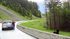
Sometimes it’s more fun to people-watch – especially when they get too close.  That short concrete barricade isn’t going to do much to stop those two bears from mauling that lady if they get tired of eating dandelions.

When we were planning this trip, I sat down with a stack of library books and my laptop and did my best to research all the possible routes and cool things to do along the way.  As you can imagine, trying to plan out where to go and what to do every day for a five-month trip was an overwhelming task – there’s just so much information to sift through.  Plus, I didn’t want to pre-plan everything – a little spontaneity is a good thing.  We want to be flexible in case we decide to stay longer in one place or in case (god forbid!) something serious breaks on the van.  So I put together a reasonably detailed plan that got us as far as Jasper.  But now that we are past Jasper, we really only have two firm reservations – our Alaska ferry ride next week, and our time in Denali in mid-July.  So from here on out all the details are sketchy as to what towns we’ll stay in and how many days we will stay in one place, and what the local attractions are.  We are just taking it on a day-by-day basis.

There was a small traffic delay on Highway 16 as workers tried to figure out how to tow this unlucky semi.  From what we gathered, he tried to pull over onto a soft shoulder that gave way underneath him and tipped the rig over.  Yikes.

Many of the towns on the Yellowhead Highway (Highway 16) are pretty much one-horse quiet little towns with not much going on, so some of the posts this coming week might be a little boring or brief.  Up ‘til now most of our posts have been destination-oriented – a national park, or a tourist attraction, etc. – but since there aren’t too many major sights on this part of our route, this week will be more about the journey instead of the destination.  We did find out about a cool detour up to one of the smallest towns in Alaska (Hyder, right on the Canadian border), so we’ll actually be briefly setting foot in the Last Frontier state about a week earlier than we’d originally intended.  Cool.
One of the things we are trying to avoid is making reservations too far in advance.  Like I’ve said, we want to be spontaneous.  But we are realizing that some of the more popular places are starting to get crowded now that it is mid-June and everyone is taking their summer vacations.  This was the line to check in at Whistler’s campground in Jasper.  We didn’t have reservations, and for one of the nights our only choice at this campground was a site with no electric and water hookups.  It wasn’t a problem since we had full tanks and full batteries, but it does have me second-guessing our fly-by-the-seat-of-our-pants strategy a little bit.
DSC03360
It seems like half the people we run into are Alaska-bound.  In a way, it’s similar to when we were cruising and all the other boats were pretty much heading the same direction up or down the island chain depending on the season.  One major difference is that you don’t often run into the same people, since there are so many different routes, towns, and campgrounds.  With boating, anchorages and routes were a little more limited.  Plus you could always listen in on the VHF and if you heard a familiar voice or boat name it made it really easy to keep track of whoever was anchored nearby.  CB radio, anyone?  Breaker-breaker, any taker – what’s your handle good buddy?