Showing posts with label U.S. State Parks. Show all posts

Sunday, November 18, 2018

Hawaiʻi - Waikiki Beach and Oʻahu


There’s something about Hawaiʻi that keeps calling us back. In the past ten years we’ve been to the other main islands (Maui, Kauaʻi, and the Big Island of Hawaiʻi) so we thought this time we should check out Oʻahu. We booked a quick one-week trip through Costco to Waikiki Beach.

Duke Kahanamoku statue on Kuhio Beach

Kuhio Beach

We stayed at the Outrigger Waikiki Beach Resort, which was in a perfect location right on the beach and within walking distance to lots of great restaurants. Our balcony even had a (partial) ocean view. (We also had a full view of the balconies of the hotel next to us; it’s always interesting to look across while sipping a sundowner and see about a hundred other people staring back at you).


Our room was decorated in – what else? – a Hawaiʻian theme.


From the beach in front of the hotel, we had great views of Diamond Head, a huge volcanic cone that is one of Oʻahu’s most-recognizable landmarks.


The other great thing about the Outrigger beach resort is that they have a fantastic jazz venue on site, The Blue Note. We went to two shows here during our stay and it is a great place to see a live performance – there are only about 300 seats and all of them have a great view of the stage. Lots of big names perform here even though it’s a small venue because, hey, free trip to Hawaiʻi.


We rented a car for one day and drove the loop around the island, starting our morning at the USS Arizona Memorial in Pearl Harbor. The Park Service is currently repairing the dock at the Memorial, so we couldn’t disembark and see inside, but it was a very moving experience just to be there and reflect on the many sailors and Marines who lost their lives on December 7, 1941.


Our next stop was at Haleʻiwa Aliʻi Beach Park on the North Shore to watch the Van’s Triple Crown surf competition for an hour or so. The waves were huge and the surfers were just tiny specks in the blue sea, but the hilarious commentary over the loudspeakers filled us non-surfers in on every drop, cutback, and wipe out, and helped us make sense of what we were seeing.


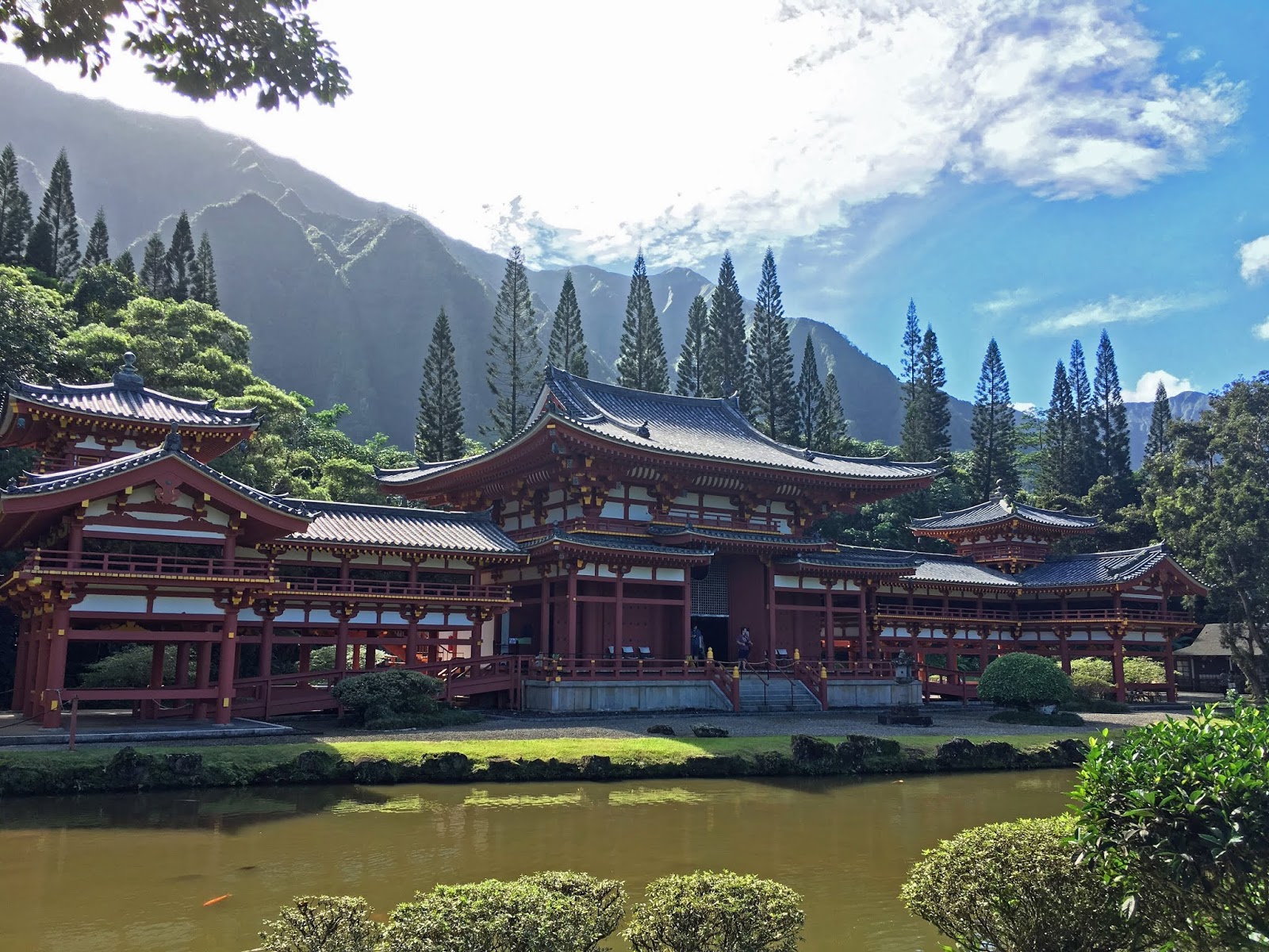
As we made our way to the eastern side of the island, we stopped at the Byodo-In Temple which is a half-size replica of Japanese temple of the same name. Since we plan on heading to Japan in spring 2019, this was an interesting place to visit – we plan on seeing lots of temples while we are in the Land of the Rising Sun.


Our last stop with the rental car was at Kualoa Regional Park, where we had great views of the Koʻolau Mountain Range, which has been the backdrop for many films and TV shows including Jurassic Park, Lost, and Magnum PI.


As I mentioned, we only rented a car for one day, but the local bus on Oʻahu is cheap and easy to use to get around. We took the bus into downtown Honolulu to check out the beautiful ʻIolani Palace, America’s only official royal palace and a National Historic Landmark. It was decorated in Monarchy-era bunting in honor of what would have been King Kalakaua’s 182nd birthday.


We were also able to take the bus to the world-famous snorkeling site at Hanalei Bay. It was packed with people, and it is so popular that they actually close the site down one day a week in order to try to let the coral recover from all the snorkelers. Unfortunately the coral still looked mostly bleached to us. Although the snorkeling was kind of a bust, at least there were gorgeous views of the bay from the trailhead.


Hawaiʻi is a food-lover’s paradise, and of course we had plenty of kahlua pork, poke, and loco moco on this trip. We also made sure to have at least one token meal that included SPAM.


Too. Much. SPAM. (And way too many pancakes, too!)

But something new that we tried on this trip were malasadas from Leonard’s Bakery. Malasadas are the Portuguese version of little jelly doughnuts, covered in sugar and filled with all kinds of sweet jams. We tried a variety of them – the guava flavor was my favorite.


This was Kevin’s second trip to Oʻahu and my first, but there was just so much to do and see on the island that I know we’ll be back again soon. Aloha!


Sunday, July 6, 2014

Horseshoe Bend and Antelope Canyon

Our big Grand Canyon rafting trip doesn't start until tomorrow morning but we decided to head north a day early so that we could take a detour to Page, AZ and check out the sights.  The Colorado River is west of Page, and just outside of town is a great spot to view the river -- Horseshoe Bend.

The river makes a snaking 180-degree turn.
If you look closely at that photo, you can see a tiny raft down there in the river.  There are several companies who offer 1/2 day or 1-day float trips on the calm section of the river just below Glen Canyon Dam.  Of course, we are looking for a little more action than that. 

There were hundreds of people at the overlook, and lots of them were getting awfully close to the edges of the cliff overhangs.  Obviously there is no guardrail here, so visitors are presented with many opportunities to win a Darwin Award.  I was glad we were using the "Go Pro on a stick" method of photography so that we didn't have to get too close to the edge to get a decent selfie.


We then headed over to Antelope Canyon, a beautiful sandstone slot canyon that has been carved over millennia by flash floods caused by monsoon rains.  This process is still going on today.  The walls of the canyon have been worn smooth by time and the elements.


There are two sections: the Upper Antelope and Lower Antelope Canyons.  Each can only be visited as part of a tour.  The upper canyon parking lot was full of tour buses and we hadn't booked ahead, so we chose the lower canyon and only waited 5 minutes for the next tour.  Our tour guide, Ivanna, grew up in the area and is now a student at the University of Arizona, guiding tours during her summers off.  She took our small group down the stairs into the canyon and pointed out some of the best spots for photos.


We learned that the canyon is still prone to flash flooding and can fill up fast.  When it rains upstream in the canyon basin, all of the water is funnelled into the narrow canyon and can easily sweep people off their feet.  This is what the canyon looks like from the rim during a flash flood:
Video credit: TheMrByrom via YouTube

I would not want to be in there during a rainstorm!  Luckily there was no chance of monsoon rain today.  Here's the view we had:

About 50 feet below the rim, looking directly up at the sky.
And a short video we took, with views of both Horseshoe Bend and inside Lower Antelope Canyon:

Saturday, August 25, 2012

San Juan Islands, WA: Orcas Island

The San Juan Islands are a small island group located between Washington and Canada.  Years ago Kevin went on a five-day kayaking trip through here, and he’s always wanted to come back and explore them by car.  We caught an early morning ferry from Anacortes and arrived on Orcas Island just in time for lunch.

The town of Orcas, one of about three towns on the island.

The island is small, only about 57 square miles, with a population of about 5,000 people.  It’s definitely a rural setting – there are no stoplights but plenty of orchards and farms.  The scenery is gorgeous, and the view from Mt. Constitution (the island's highest point) gives you a great view of all the other islands (and the mainland, on a clear day).

On Friday afternoon, we did a nice hike around Mountain Lake in Moran State Park, then headed to our campsite at Cascade Lake.  The campsites were a little close together, but it was a beautiful day to be outdoors.

On Saturday morning, we spent some time in Eastsound, the island’s largest town.  The main street has a lot of artsy shops and a couple of pretty public beaches.

The Saturday Farmers’ Market was in full swing.

We had a ferry to catch, but that didn’t stop us from wandering past each of the stalls and sampling some of the fresh fruits – organic strawberries and Shiro plums.  They were perfectly ripe and sugary sweet.

Friday, August 24, 2012

Great Alaskan Road Trip: Week 15 Roundup

Each Friday, I post some relevant (and not-so-relevant) stats about the trip, as well as a little write-up of what it’s like to live out of a van for weeks on end. Here’s where we are overall:

  • Total miles driven: 10,261
  • Total miles by ferry: 537 
  • Total days on the road: 102
  • Total nights in a hotel: 4
  • Total miles hiked: 105.94

It’s easy to see why our Milepost guidebook calls the area south of Cache Creek, BC the “Arizona” of Canada. 

Some interesting stats for this week:

  • Fuel stops: 5 (diesel: as low as $4.25/gal in Bellingham, WA up to $4.88/gal in Prince George, BC)  
  • Bears sighted: 2
  • Buffalo sighted: about 30
  • Manta Catamarans sighted: 1

Say…that looks like our boat!  We recognized the distinctive profile of this Manta catamaran anchored off Lopez Island in the San Juans.

It’s been a looong week of driving, but yesterday we made our final border crossing back into the United States.  Yay!  Total number of border crossings for the trip: 12.  This time we had to wait in line at the border with all the Canadians who were heading south for cheap gas and groceries.  We were in line for about an hour, then I made the mistake of “declaring” that we had six – count ‘em six – cherry tomatoes in the fridge.  Well, that got us singled out for an Agriculture inspection which meant that our van was searched inside and out for any additional stray tomatoes or other veggie contraband.  If I had known the delay those stupid tomatoes were going to cause, we would have just eaten them while we were waiting to get to the checkpoint!  Needless to say, our tomatoes were confiscated, and we finally made our way to Bellingham.

We were eager to get to the RV park because we’d ordered our mail delivered, and the package included our Arizona license plate tags for the van (which expire at the end of August, so we were cutting it close.  I was worried about what might happen if we got pulled over in Canada without having proof of valid registration.  We wouldn’t want a repeat of what happened with our Coast Guard documentation back in Martinique!)  Luckily our mail was waiting for us when we arrived, we put our shiny new tags on our license plate, and were once again law-abiding citizens.  Welcome to Washington!

Monday, May 28, 2012

Logan and Garden City, UT

DSC01666When we were planning out the trip, we tried not to make too many reservations ahead of time.  But we did go ahead and reserve our campsites for Memorial Day weekend, just in case things were crowded.  We had reserved a spot in the Cache National Forest near Logan, in northern Utah, and as luck would have it, our friend and coworker Doug and his family live not 7 miles from there.  They invited us for Sunday barbecue dinner with their family (and extended family).  It was such a fun and lively gathering and the food was delicious – best meal we’ve had all week!  The family atmosphere made me miss my far-flung siblings (in Italy, Costa Rica, Scottsdale, Santa Barbara, Thailand) and parents back home.  I miss all you guys!
DSC01677The Logan Canyon area is just gorgeous, with larger-than-life mountains and a picturesque river running alongside the roadway.  The peaks of the mountains were still snow-capped, and as we continued to climb in elevation the snow came right up to the road.  It was a very nice drive (no ice on the roadway) and we didn’t have very far to go today – just about 32 miles to Bear Lake, a crystal-clear lake that borders Utah and Idaho.
DSC01684
It looks chilly, but once we got down to Garden City there wasn’t any snow on the ground.  We (well, me) still thought it was a little cold, but almost everyone else we saw was wearing DSC01686shorts and t-shirts so I guess we’re wimps.  But Doug’s wife Lisa had suggested we stop at Le Beau’s for a raspberry shake (the town is known for its fresh raspberries) so despite the fact that we were all bundled up we did sit outside and enjoy a nice frosty milkshake.  Once the sun came out it was actually very pleasant, and there was a heavenly fragrance in the breeze from the nearby lilac tree.
After settling in at the campground (now that Memorial Day weekend is over we are practically the only ones here), we took a walk down to the marina for a closer view of the lake.
DSC01698
The marina was home to quite a number of boats, and there were a couple of sailboats out on the water even though it wasn’t very windy.  One of our brochures calls Bear Lake the “Caribbean of the Rockies” because of its bright turquoise color and clarity of the water.  Our photos don’t do it justice, but we could see how it got the nickname because there definitely was a hint of Caribbean blue in the water.  Then again, maybe it was the seagulls.

Tuesday, May 22, 2012

Canyonlands National Park -- Island in the Sky

We left Arizona to escape the heat, but it was nearly 99 degrees in Moab today.  Yeouch.  Probably not the ideal temperature for hiking and exploring Canyonlands National Park, but with the breeze it wasn’t really too bad.
DSC01524
DSC01488
The park is so vast that it is divided into three districts – The Maze (the most remote section – no paved roads), The Needles (which we passed up yesterday – not enough time to do it all on this trip, unfortunately), and the aptly named Island in the Sky.  This is the most accessible area of the park, with plenty of pull outs for viewing and hiking.

It’s called the Island in the Sky because this part of the park is on a broad mesa that is bordered by the Colorado River on one side, and the Green River on the other.  Both rivers have whittled away at the sandstone layers leaving the mesa standing alone – like an island.  In the sky.

DSC01485
We did a couple of nice easy hikes: the Mesa Arch loop and the Grand View Point overlook.  From the Grand View Overlook you can see the nearly-pristine wilderness spread out before you.  For the most part, people seem to respect the natural state of the park, but at least one artist has left his mark on the sandstone near the end of the Grand View trail.

DSC01521DSC01518
On the way back to Moab, there is a turnoff for Dead Horse Point State Park, which has some fantastic views of the Colorado River as it winds its way through the canyons below.  The brochure we were given says this about how the park got it’s name:
  “The point was once used as a corral for wild mustangs roaming the mesa.  Cowboys rounded up these horses, herded them across the narrow neck of land and onto the point.  The neck, which is only 30 yards wide, was then fenced off with branches and brush, creating a natural corral surrounded by precipitous cliffs.  Cowboys then chose the horses they wanted and for reasons unknown, left the other horses corralled on the waterless point where they died of thirst within view of the Colorado River, 2,000 feet below.”
It’s a heartbreaking story, but what a view!

Sunday, May 20, 2012

Monument Valley: Annular Eclipse

“Once upon a time I was falling in love.  But now I’m only falling apart…”  Somehow “annular eclipse of the heart” just doesn’t sound right, does it?

Today was a relaxing day.  When on vacation, we usually want to “see it all” and then wind up exhausting ourselves by the end.  But we can’t do that on a long trip like this, so we are planning a day every week or so where we relax a little and don’t do a full day of sightseeing or driving.  Today we went for a morning hike through a box canyon near the campground, then came back to get caught up with email and internet stuff.

DSC01179

Around 5 pm, we drove the van over to the Monument Valley visitor’s center to set up for viewing the solar eclipse.  It’s an annular eclipse, which means that the moon is far enough from the earth so that it doesn’t block out the sun completely (a total eclipse), instead leaving just a ring of sunlight silhouetting the moon.  The “ring” is only visible from certain parts of the world, and Monument Valley happens to be right on the path.  From here it was the tiniest bit off-center, but still had a full ring around it.

Before we left Phoenix, we bought a few of these eclipse viewers.  They don’t look like much, but they did the trick of allowing us to view and photograph the eclipse as it happened.  We didn’t see anything like this on sale in any of the gift shops here, so we were glad we’d brought along our own.  We saw several people taking photos of it and viewing it from behind their iPads.  I guess that might’ve worked, too – if we had an iPad.  We’d be curious to see how their pictures turned out, though.  When we took photos without the filter it was just a wash of bright light with no detail discernable.

DSC01185DSC01310

The eclipse lasted about two hours, but there were only a few minutes where the ring was fully visible.  We set up camp so we could watch the whole show, beginning to end.  We put out our table and chairs, ate dinner, and periodically checked on the eclipse and took photos right up until the end.  In order to take photos, Kevin had to hold the camera steady behind the eclipse viewer, so getting some good shots took a lot of trial and error.  Kevin sorted through the 250 or so photos to put together this cool collage of images.

eclipse montage angle

As I said, we were there for the whole show and were still watching it well after most people had packed up and gone home.  Our diligence was rewarded with this awesome sunset while it was still eclipsing – now, there’s something you don’t see everyday!

Saturday, May 19, 2012

Monument Valley, Arizona/Utah

DSC01053
The iconic Monument Valley straddles the border of Arizona and Utah.  The park is on Navajo tribal land and actually it isn’t part of the National Parks System. Instead it is maintained as a Navajo Tribal Park.  Kevin had been to this area before, years back, and he thought he’d seen what there was to see.  But as we found out today, there is much more to Monument Valley than what you can see from the highway.  In fact some of the park’s best views aren’t visible from the highway, or even from the visitor’s center.

 Most of the Valley’s monuments are best seen by car from a 17-mile rough dirt road.  The road is open to the public, but we really weren’t too keen to take the van off-roading.  So instead we called Navajo Spirit Tours (ranked #1 on Trip Advisor, for good reason) and booked an afternoon tour.  It turned out to be the best thing we could have done.
DSC01135Garry Holiday, a Navajo guide who grew up in this area, runs the tour outfit with his wife Michelle.  They picked us up in their 4x4 truck – they had several rows of shaded seats fitted into the back of the truck bed.  It turned out to be a private tour, since no one else had booked for the afternoon.  Which was great for us, especially when we saw how some of the other tour companies really packed them in.

DSC01078Once we saw the dirt road, we were especially glad we hadn’t brought the van out there.  The road was pitted in some places and steep in others, with rocks and ruts that could take out the undercarriage of your car if you weren’t careful.  We did see a few gutsy people driving it in Cameros, Mustangs – even a Prius.  So it can be done on your own, but you get so much more out of it with a guide.  Garry made it a point to pull off in the less crowded spots, where we would all get out of the truck and he would explain the significance of the formations to the Navajo people.  Since so many movies and commercials have been filmed here (Stagecoach, The Searchers, Wind Talkers, National Lampoon’s Vacation, to name a few), he also made sure to point out where certain shots were filmed.
Totem Pole Formation, a thin spire of rock 450 feet high

Garry and Michelle took us through the public part of the road, as well as a restricted road through the valley that you can only access with a guide.  We saw several settlements along the way – most of the park is private land and there are traditional homesteads here where Navajo families farm and graze sheep.  We stopped at the hogan of Susie Yazzie, a skilled Navajo weaver who has been living here for more than 100 years.  She showed us first how she carded the raw wool, then how she spun it into yarn that would be dyed and used to weave rugs.  She had a gracious spirit and a contagious laugh.  She was joking about something but since she was speaking Navajo, we didn’t catch the punchline.
DSC01077
Garry told us that the Navajo people believe that Monument Valley is like a body, with hands (the mitten rock formations) and other body parts.  This natural arch is called the Ear of the Wind.
DSC01094
And this enormous arch is called the Sun’s Eye.  We were the only people there at first.  While Kevin and I gazed up at it, Garry sang a traditional song and played the drum for us.  Shortly afterward, one of the other tour company’s trucks brought a larger group of people.  You can see their group at the base of the rock, to give you an idea of the scale of the Sun’s Eye formation.
DSC01105
One of the best parts of the tour was when our truck met up with another tour being guided by Garry and Michelle’s daughter, Miesha.  They took us to a natural amphitheater and performed four songs, the three of them playing drums, guitar, and the Navajo flute.  At the end Miesha sang the National Anthem, only she sang it in Navajo.  She sang beautifully and her clear voice was amplified by the curvature of the rock behind us.  As I stood there with my hand on my heart, there were tears in my eyes.  So needless to say, if you are ever in Monument Valley, I cannot recommend Navajo Spirit Tours highly enough! 

Garry has given his permission for us to include an mp3 of one of the songs he played.  Here he is playing the drone flute, which can play two notes at the same time.  If you listen, it sounds like two flutes but really it is just one instrument.  The acoustics in the natural amphitheater were fantastic, not sure if this recording does justice to the hauntingly beautiful sound.


After the tour, Kevin and I checked in at the campground and had a snack before heading back over to capture a photo of the Mittens at sunset.  Gorgeous, isn’t it?  I swear, each day of this road trip seems to be better than the last.
DSC01152
From left: West Mitten Butte, East Mitten Butte, Merrick Butte